

 Cedar Rapids, Iowa
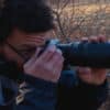

 Adetunji K
At a previous job I spent a lot of time running missions for golf courses, now I have my own high end drone and I'm looking to branch out.
-
 North Attleborough, Massachusetts
- Save
-
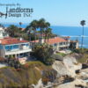
Los Angeles, California
- Save
FAA Part 107 Certified | Mapping Certified | Structure Asset Certified | CAL/OSHA 10 Certified | DJI Air 3 | DJI Mavic 3 Enterprise

- $100.00 / hr
-
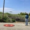
Escalon, California
- Save
I have done drone jobs for Droners.io, Dronegenuity.com, River partners.org, Local ranches and orchard owners in the CA Central Valley. BMW club of northern CA,…

- $75.00 / hr
-
Frankfort, Kentucky
- Save
Do you want to take your marketing to new heights? Want your property to stand out from the competition? As a certified FAA drone pilot…
- $150.00 / hr
-
Santa Rosa, California
- Save
Solar Inspection, Tower Inspection, Roof Inspection, Construction Mapping, Orthos, 3D Modeling, Surveying (with GCP’s set by Licensed Surveyor). Processing with Metashape Pro. Videography, Photography. I…
